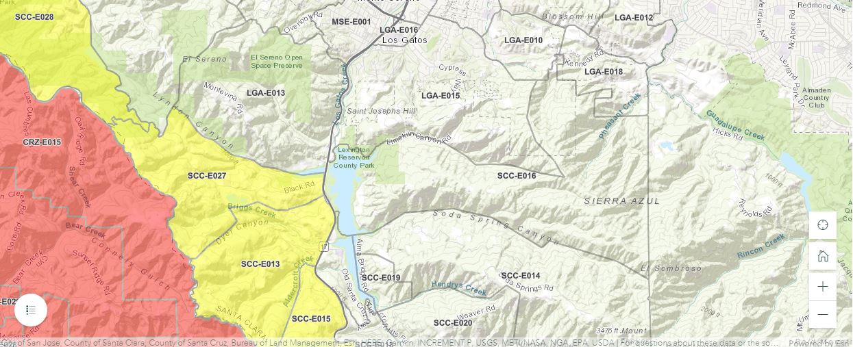
I realize that we are getting a fair number of links and the list itself needs to be categorized (eg, Air Quality; CZU fire update; Phone Notifications; etc. etc. – I’m working on that between other non-paying jobs)
If you have to evacuate, shut off the gas; put full water buckets around your house if you can; put a ladder up against the roof for the firemen; leave the windows and doors unlocked (that’s what they say!); leave the lights on so that firemen can see inside (and see the house when it’s nighttime).

Links to Fire Information:
From: Evan Abate – Los Gatos CERT (Civic Center)
Some ways to stay informed on the CZU Lightning Complex fire. First and foremost, do not take this information as official advice! I am just sharing some of the ways I use in order to be constantly updated on the status of the current CZU Lightning Complex fire that is burning in San Mateo County and Santa Cruz County (or really any fire).
1) Twitter: I use Twitter to stay up to date on the latest evacuation warnings, evacuation orders, incident updates (i.e. acreage, containment, summary, etc.), road closures, weather, as well as pictures/videos of the fire. Specifically for this incident, I suggest following these accounts: @CALFIRECZU, @CHPscrz, @CAFireScanner, @NWSBayArea, @sccfiredept, @LGMSPolice, @TownLG, @calfireSCU, @PGE4Me, and @jadenschaul (photojournalist). @CAFireScanner and @jadenschaul do not provide official information and should not be treated as such but they do provide very good information to personally consider.
2) County of San Mateo and County of Santa Cruz Evacuation Map. This map advertised and updated by both counties to provide current evacuation *warnings* and current evacuation *orders*. (The website may be slow due to the number of people trying to access it and may not be mobile friendly)
Link: https://community.zonehaven.
Link: https://www.purpleair.com/map?
Link: http://www.alertwildfire.org/
7) PG&E Electrical Outage Map. PG&E provides an electrical outage map where you can view locations to see if there is an electrical outage. It shows information like size of outage (on map visual), number of affected customers, start time of outage, estimated restoration of power, possible reason for outage, and the status of the outage. If your power is out and you do not have access to the internet, you can call PG&E @ 1 (800) 743-5002.
Link: http://critweb-outage.
Link: https://www.fire.ca.gov/
Again, do not take this information as official advice! Use these resources to gain a better understanding of what these fires are all about. I WILL advise you to read the official information coming from agencies like CAL FIRE (specifically the San Mateo and Santa Cruz Unit – CZU) as well as our own fire department, Santa Clara County Fire Department, on this CZU Lightning Complex fire.
Now is an especially great time to start thinking about emergency preparedness! The Santa Clara County Fire Department has a program called “Ready, Set, Go” that talks about ways to be prepared for wildfire. It discusses defensible space around property, hardening your home, having a plan, creating an emergency supply kit, preparing for evacuation, and what to do when wildfire strikes.
I can’t stress enough the importance of heeding evacuation warnings and orders from law enforcement and fire departments. If you receive an evacuation WARNING, it means that evacuations are very likely and you should prepare to leave. If you receive an evacuation ORDER, you should not delay and leave ASAP. This is why having a plan and being prepared is so important, if there is an evacuation warning or order, you are already ready to go.
______________________________________________________________________________________________________________________________________________________
From Jak @CERT Los Gatos (Civic Center)
https://incidents.
Alert SCC: https://member.everbridge.net/
Nixel: notices for your zip code: text your ZIP CODE to 888777 for mobile alerts
Cal Fire-Preparation Site
https://www.readyforwildfire.
air quality – smoke map
road conditions ( think you can still dial 511 on your phone and get road conditions)
From Michael Parker Cert Los Gatos (Civic Center)
https://www.windy.com/?850h,
https://www.purpleair.com/map?


Rick Van Hoesen
Regarding the Michael Parker’s air quality link to PurpleAir, it is possible to “hide” indoor sensors like the one at the LGHS gym. You can do this by unchecking “Inside Sensors” in the popup in the lower left of the web page. Or you can just click on this link: https://www.purpleair.com/map?opt=1/i/mAQI/a10/cC0#13.75/37.22806/-121.97508.
You may also want to select “LRAPA” rather than “none” in the area under “Conversion.” This purports to normalize the results to make them more consistent with official government air sensors. Details on the LRAPA conversion are available if you click the question mark next to “Conversion.” To see the map with the LRAPA conversion enabled, click this link: https://www.purpleair.com/map?opt=1/i/mAQI/a10/cC4#13.75/37.22806/-121.97508.